

Nepal’s Himalayan Floods: Unravelling the Causes, Assessing the Risks, and Preparing for What Comes Next
A look at how the 26 August 2026 disaster unfolded, what it means downstream, and how the region can read the warning signs next time
Tracing the Chain of Events
On 26 August 2026, the Rasuwa district of Nepal, close to the Nepal–Tibet border, was struck by one of the most destructive flash floods the Himalayan region has seen in years. A sudden surge of water, ice, rock and debris tore through villages, roads, bridges and hydropower infrastructure. By early September, the toll stood at over 1,100 people dead and thousands more missing, making it one of the deadliest disasters to hit the region in recent memory.
The scale and suddenness of the destruction initially led many to assume an earthquake had triggered it. But as scientists and satellite agencies began piecing together the evidence, a far more complex with more instructive picture emerged. This was not a single random event, but the endpoint of a chain reaction that had likely been building for weeks.
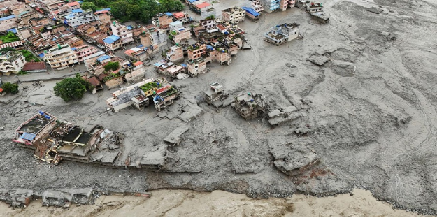
Image 1 : Aerial view of the destruction in Nepal's Rasuwa district, with homes and infrastructure buried beneath mud and debris. (Reuters, 2026)
The Forces Behind the Flood
Early seismic readings picked up a strong signal around the time of the flood, which is what first pointed investigators toward an earthquake. Closer analysis, however, showed that the seismic signal was not the cause of the disaster, it was a consequence of it. The "quake" that instruments recorded was actually the shock wave of a massive glacier-rock collapse.
Satellite monitoring in the weeks before 26 August had already picked up something unusual: a glacier-rock mass above the valley was moving faster than normal. That accelerating mass eventually gave way, sending an ice-rock avalanche and a wall of debris crashing into the Lhende Khola stream. The flow then merged into the larger Bhote Koshi and Trishuli river system. Further, the steep and narrow terrain of the Himalayas accelerated the flow, intensifying its destructive force as it surged downstream.
Climate change is an important underlying factor in this story, but it is not the sole driver.Rising temperatures are steadily altering glaciers, snow cover and permafrost across the Hindu Kush Himalayan range. This can make slopes like the one above Rasuwa more prone to sudden failure. Scientists are careful to note that pinning this one disaster entirely on climate change would be premature but the broader trend of a warming, destabilizing mountain environment interacting with steep terrain and human development is exactly the kind of risk multiplier the region will keep facing.
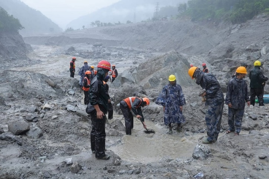
Image 2 : Rescue teams working through mud and debris following the flash flood in Rasuwa district. (Down To Earth, 2026)
Were There Warning Signs?
Yes and this is perhaps the most important part of the story. Satellite surveys had already flagged that the glacier system above Rasuwa was changing state before the disaster struck. That doesn't mean anyone could have predicted the precise hour the slope would fail. An early warning of this kind rarely offers that level of precision. What it does mean is that the unusual movement was detectable well in advance, if the right monitoring and response systems had been watching for it.
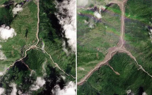
Image 3: Copernicus Sentinel-2 satellite imagery showing the Langtang Lirung glacier area before and after the disaster — the widened, debris-covered river channel is clearly visible. (European Space Agency, 2026)
That distinction matters. The lesson from Nepal is not that every disaster can be forecast to the minute. It's that the signals, accelerating glacier movement, shifting river patterns, changes in permafrost are often there before the event, waiting to be read.
The Downstream Story: What It Means for India
Himalayan disasters rarely stay within the borders where they begin. The Bhote Koshi-Trishuli river network that carried this flood downstream ultimately connects into the Gandak river system, which flows into India. Nepal’s rivers are also closely connected to the wider Koshi and Gandak river systems, which serve as lifelines while also shaping flood risks across large stretches of the Indo-Gangetic Plain.
For Bihar and parts of eastern Uttar Pradesh, this is a direct reminder that flood risk doesn't start at the Indian border rather it starts wherever the river does. An extreme event upstream in Nepal can translate into sudden flooding, riverbank erosion, heavy sedimentation, water-quality problems, disrupted transport and livelihoods, hundreds of kilometres downstream.
This is why experts increasingly describe Himalayan hazards as transboundary risks rather than purely national ones. A glacier collapse in Rasuwa is, functionally, an early warning for river systems that eventually reach Indian towns and farmland.
From Disaster Response to Risk Preparedness
The clearest takeaway from this disaster is the need to shift from disaster response toward disaster anticipation. That requires stitching together several different data streams that, individually, only tell part of the story: satellite imagery, glacier movement tracking, rainfall data, river discharge levels, and seismic observations. On their own, each is a fragment. Together, they can form a genuine early-warning picture.
Nepal has already signaled plans to strengthen its early-warning network with additional seismic sensors, cameras and satellite communication links, alongside improved real-time monitoring of glaciers and glacial lakes. That's a necessary step but monitoring only saves lives if it's connected to something people can actually act on.
Technology is only as good as the last mile. Warnings need to reach villages, hydropower project sites and transport corridors through clear evacuation protocols, community-level communication networks and mobile alerts, rather than monitoring dashboard remotely. A satellite that spots an accelerating glacier is only useful if that information turns into a phone alert, a siren, or an evacuation order in time.
Rethinking Infrastructure and Land-Use
Roads, bridges, hydropower stations and settlements built in narrow Himalayan valleys have historically been planned around past flood records. Those records are becoming less reliable as a guide to future risk. Infrastructure planning across the region needs to be tested against future multi-hazard and climate scenarios, not just historical baselines, and risk-sensitive land-use planning needs to become the default rather than the exception in vulnerable mountain valleys.
Building a Shared, Cross-Border Resilience Agenda
Because Himalayan rivers, glaciers and hazards pay no attention to national boundaries, no single country can manage this risk alone. Nepal, India and China all have a stake in improving how hydrological, meteorological, seismic and cryospheric data is shared across borders. Stronger regional cooperation, joint monitoring, shared early-warning data, coordinated river-basin management would let downstream communities in India benefit from warning signs picked up far upstream in Nepal or Tibet, and vice versa.
Climate adaptation can't be treated as a purely environmental issue. It's tied directly to decide about where infrastructure gets built, how river basins are managed, and how fragile mountain ecosystems are protected considering both Nepal and India, along with their neighbouring countries.
The Larger Lesson
The Rasuwa floods are more than a reflection of what happened on 26 August 2026. They are a warning of what could happen again not only in Nepal, but across India and elsewhere along the Himalayan arc. The critical question is whether the region will be prepared to recognize the warning signs early enough, before the next mountain hazard unfolds. The glaciers, rivers and unstable slopes of the Himalayas do not recognize political borders. Increasingly, neither can the systems designed to monitor these hazards, share information and provide early warnings. Strengthening cross-border cooperation will be essential to anticipating and managing risks across the region.