
Eyes in the Sky: The Geospatial Revolution against Climate Change
- by Lipsa Pradhan (Research Associate, GIS), The Celestial Earth
Understanding climate change is essential in this day and age, which is characterized by rising sea levels, melting glaciers, unpredictable weather, and a major loss of biodiversity. Thankfully, satellites orbiting thousands of kilometers above us are our strongest allies in this battle, not just scientists on the ground. These "eyes in the sky" have subtly sparked a geospatial revolution that is altering how we track, simulate, and respond to climate change globally.
From Manual to Orbital: A Paradigm Shift
Historically, ground-based instruments like weather stations, rain gauges, and ecological surveys were used for climate monitoring. During sporadic visits, scientists and field officers took notes on temperature, rainfall, soil moisture, and crop or forest health. This approach had limited coverage, was slow, and required a lot of work, even though it produced detailed information. Coastal regions, deep forests, and mountainous regions frequently lacked adequate data. Furthermore, it took weeks or months to gather, digitize, and analyze climate data, delaying reactions to important occurrences like droughts. India's drought monitoring, for instance, used to rely on rainfall variations from dispersed stations, which caused delays in identification. These difficulties demonstrated that conventional approaches were insufficient. The growing need for timely, consistent, and large-scale data led to the development of satellite-based Earth observation systems.
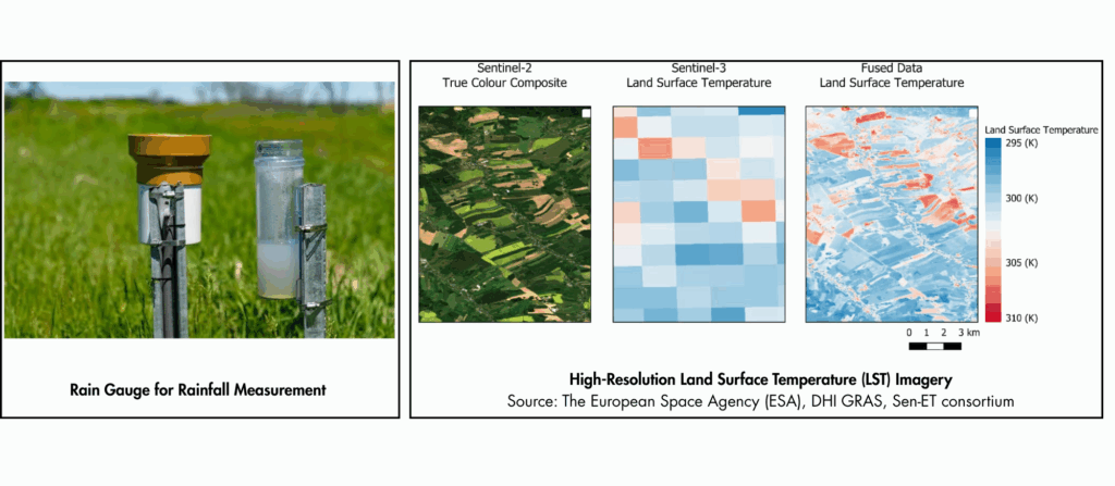
The alternative provided by today's satellite-based Earth observation systems is revolutionary. The United Nations Office for Outer Space Affairs (UNOOSA) reports that there are currently over 11,000 operational Earth observation satellites, many of which are devoted to monitoring environmental factors. Global coverage, real-time monitoring, and high-resolution data on critical climate variables, including vegetation health, land surface temperature, snow cover, and ocean dynamics, are provided by instruments like MODIS, Sentinel-2, and Landsat. In just a few minutes, these satellites can cover vast and isolated regions. This capacity makes it possible for researchers and decision-makers to identify, monitor, and address climate change far more effectively than in the past.
Monitoring a warming planet
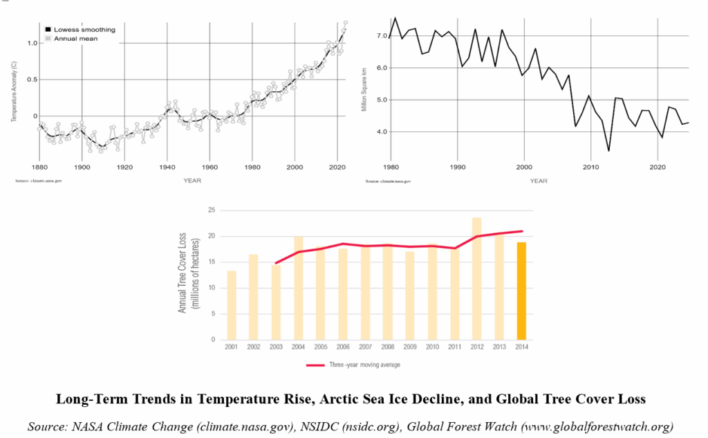
Satellite data has helped us visualize climate trends like never before.
-Global surface temperature has increased by 1.28°C since the late 19th century (NASA, 2024).
-Arctic sea ice is shrinking at a rate of 12.2% per decade since 1980 (NSIDC, 2024).
-Between 2000 and 2024, Earth lost over 488 million hectares of tree cover. This loss is equivalent to 12% of the planet's forests (Global Forest Watch, 2024).
These are not just numbers; they are mapped realities. With tools like Google Earth Engine, Global Forest Watch, and Bhuvan (India’s geoportal by ISRO), anyone, from researchers to citizens, can track these changes.
Precision tools for Climate Action
Beyond simple observation, geospatial technology is crucial for planning and climate response. As evidenced by the 2023 Assam floods, satellites such as ISRO's CARTOSAT offer real-time data for mapping floods in disaster management. Satellite imagery is used in agriculture by programs like FASAL and CHAMAN to track crops and predict yields. In order to support climate finance and REDD+ initiatives, carbon monitoring tools like InVEST and Co$ting Nature calculate the amount of carbon stored in forests and wetlands. Satellite data such as the LST and NDVI are used to identify Urban Heat Islands in urban areas. The creation of green infrastructure to increase resilience is guided by this data.
India’s Role in Geospatial Climate Space
By employing space technology to monitor and address climate change, India is contributing significantly to the geospatial climate revolution. The nation gathers vital information on weather, vegetation, soil, water, and land use through an expanding fleet of Earth observation satellites, including INSAT, Resourcesat, RISAT, Cartosat, and the recently launched NASA-ISRO NISAR. Platforms like Bhuvan, VEDAS, and MOSDAC provide user-friendly tools for environmental analysis and climate data visualization. These aid in agriculture, forest monitoring, and disaster management. Through programs like the NRSC Climate Data Services Portal, local organizations, NGOs, and students can now access satellite data, enhancing climate resilience at the grassroots level. India's dedication to a climate-smart future is demonstrated by its emphasis on digital public goods, such as FASAL and CHAMAN.
Conclusion:
A Future Mapped from above The shift from ground-based observation to satellite-powered geospatial intelligence marks a transformative moment in how we understand and respond to climate change. As the climate crisis intensifies, the ability to monitor, predict, and act in near real-time has never been more crucial. Satellites don’t just give us data—they give us foresight, equity in access, and the ability to craft science-driven, scalable solutions. With countries like India stepping forward through ambitious satellite programs and digital public platforms, geospatial technology is no longer a niche tool—it’s becoming the backbone of climate resilience. By embracing this revolution from above, we are not only mapping the impacts of climate change but also charting a smarter, more sustainable path forward for generations to come.